


The Polar Vortex strikes again!

Hello everyone,
It seemed appropriate to take a break from wine and discuss what’s been happening throughout the Plains. For those who may have missed it - it’s been cold. Really, really cold.
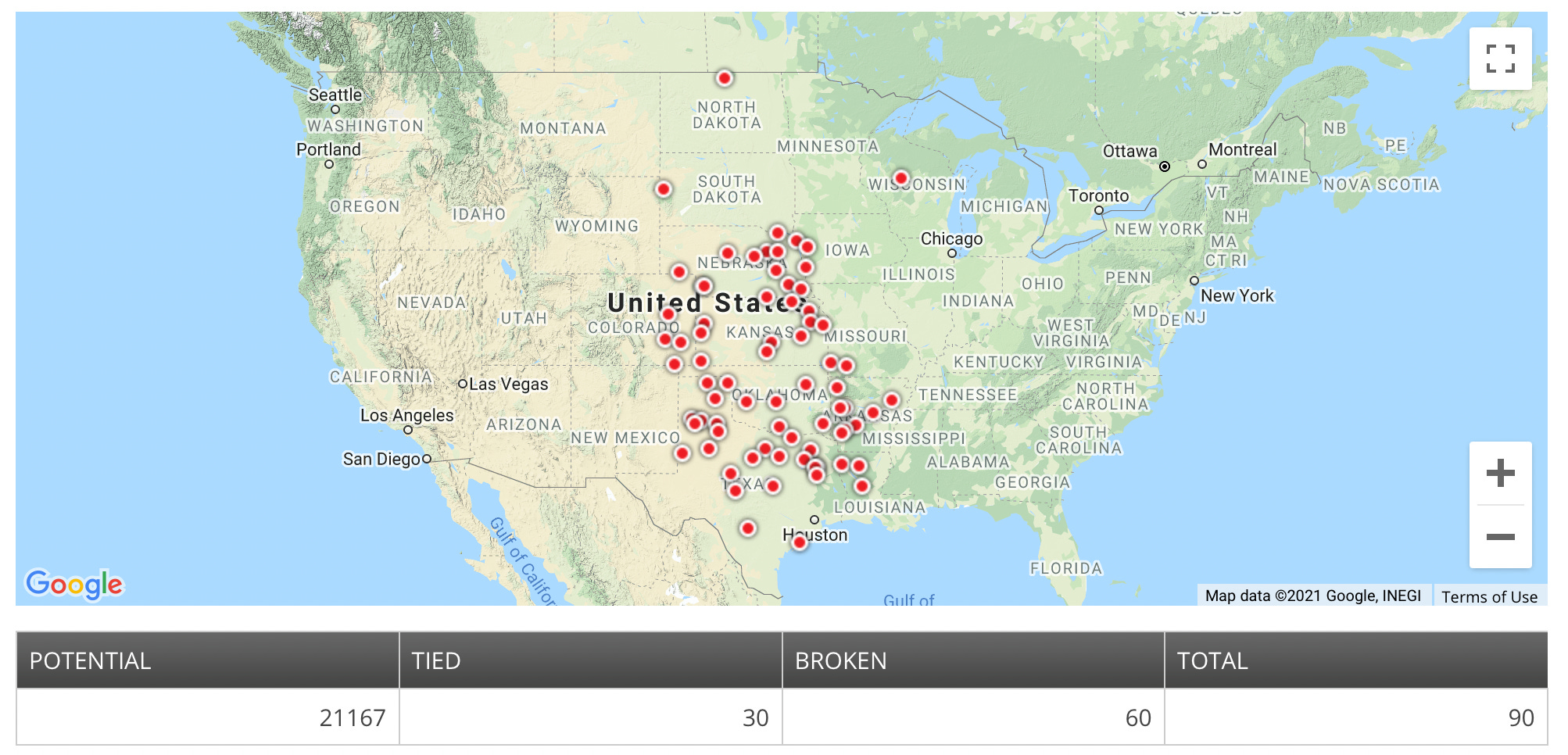
The map below shows red dots at places that broke or tied their lowest temperatures ever recorded. These record breakers were observed between February 11-17, 2021. Many of the records in Oklahoma, Texas, and Kansas were broken by more than 8°F. Eight of the records were previously set over 100 years ago and most were set before 1990.
The overnight low temperatures were absolutely bitter. Of the 90 records that were set this week, 84 were below 0°F. Owen, WI is about 140 miles due east of Minneapolis and had an overnight low temperature of -45°F. Bottineau, ND, just south of the Canada border, had the lowest temperature I could find at -54°F. Oklahoma City hit -14°F on February 17.
Why was it so cold?
I often see the term polar vortex thrown around in the media during cold outbreaks like this and this year was no exception. At its simplest, the term polar vortex refers to a permanent circulation of air that extends from the troposphere (the part of the atmosphere that we live in) to the stratosphere (about 30 miles up) and spins counterclockwise (like the earth) above the Arctic. The polar vortex spins faster during the winter than it does during the summer, but there is always some kind of rotation in the stratosphere over the Arctic. I recommend watching this quick video from the UK’s Met Office for a helpful animation before reading on.
Although the term polar vortex has become more popular over the past decade, the phenomenon is neither new nor particularly scientifically interesting. We’ve known about the polar vortex for a long time and the science behind it is actually quite simple.
Remember in the La Niña newsletter when I wrote that the secret to meteorology is temperature gradients (temperature difference between two areas)? Turns out we can use them to explain why there’s a polar vortex. Typically, air is warmest near the Equator and coldest near the North Pole. This temperature difference is stronger in the winter than the summer, but it exists in all seasons. Such a temperature gradient results in fast winds above the surface of the earth that move from west to east, often called the jet stream. In general, the jet stream is strongest when the north/south temperature gradient is strongest, which is usually in winter.
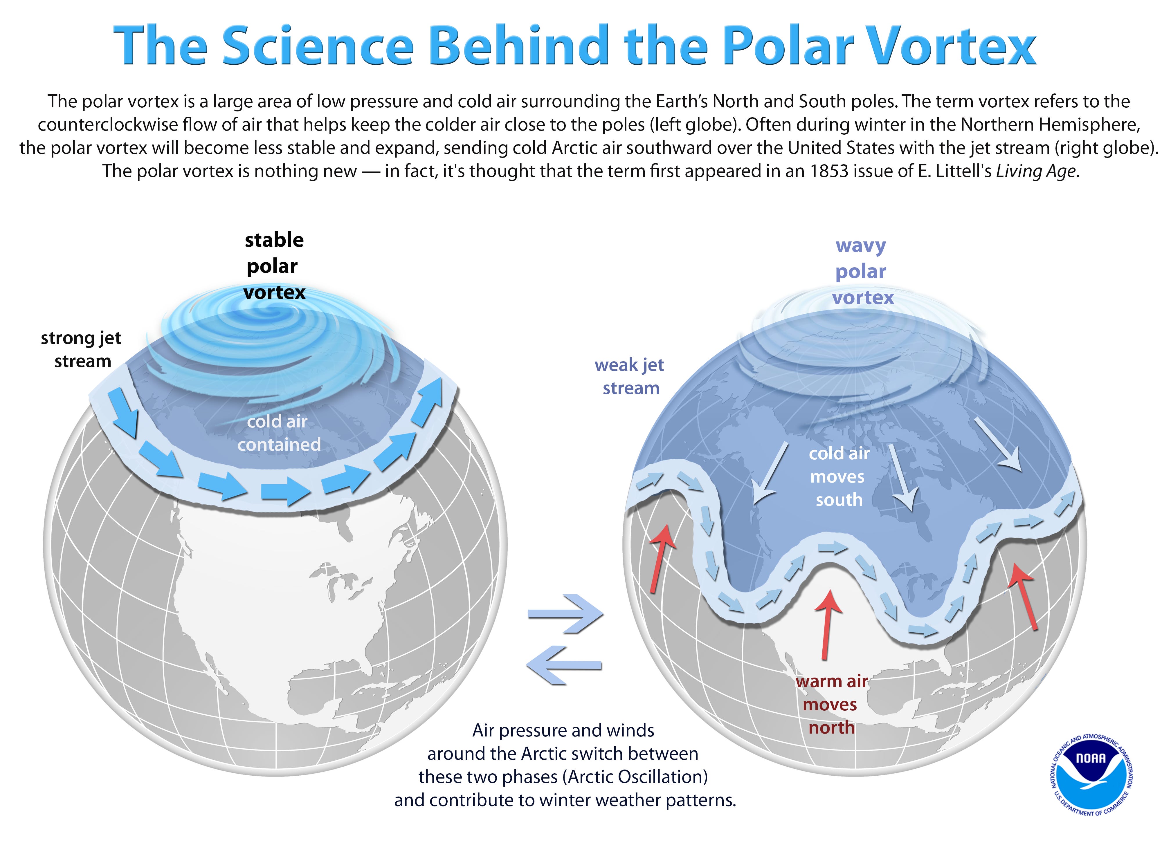
Of course, it’s not always as simple as cold in the north and warm in the south. The jet stream will rise and dip to follow these changing temperature gradients. In the image on the right above, you’ll see that cold air often comes down form the Arctic when the jet stream dips south and vice-versa. It’s these dips that lead to cold air outbreaks like the one we’ve seen during the past week.
The image below shows the jet stream (left) and cold air (right) during the past week. Notice how the jet stream dipped south of Texas into Mexico and the cold air filled in the dip.
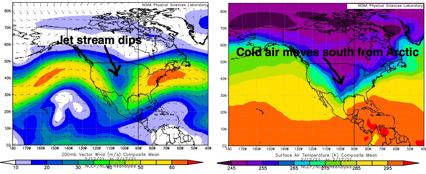
Dips in the jet stream are common during winter, but a dip that reaches as far south as the Mexico border is rare, as you’d expect from all the cold records that were set this week.
What caused this dip?
It’s hard to say for certain and I’m sure plenty of research will be published over the next couple of years attempting to answer this question. That said, I’ll give it a try.
The jet stream usually has ridges and troughs because atmospheric waves propagate along it, just like you’d expect waves to move along a string that was plucked. The atmosphere’s equivalent to plucking the jet stream can occur when strong storms hit somewhere along the jet stream, which forces it to rise in one area and dip in another.
It appears that a couple of especially strong low pressure systems that moved off of East Asia got picked up by the jet stream and pushed north in early February. The jet stream then bent north around the storms, forcing it to rise over the North Pacific and dip over the central United States.
Is the cold over? What’s next?
The coldest temperatures are likely over. The latest forecasts suggest that the cold will subside during the next week and we’ll end February with much more “normal” temperatures.
This event was so rare that the electrical and plumbing infrastructure in Texas downright failed. Of course, this turned into a political blame game, but the failure highlighted how easily cold weather can hurt people and cause property damage. Even worse, the science indicates that cold outbreaks like this will become more common (although most will probably be a bit milder). Regardless of how cold a future cold outbreak actually is, it’s important for everyone in vulnerable areas to be as prepared as possible.
Take care,
Kyle